
ၾၢႆႇ:1700 CE world map.PNG

သႅၼ်းတႃႇတူၺ်းလူင်ႈၼႃႈ: 800 × 397 ၽိၵ်ႉသႄႇလ်. resolutionsတၢင်ႇဢၼ် : 320 × 159 ၽိၵ်ႉသႄႇလ် | 640 × 318 ၽိၵ်ႉသႄႇလ် | 1,024 × 508 ၽိၵ်ႉသႄႇလ် | 1,280 × 635 ၽိၵ်ႉသႄႇလ် | 2,560 × 1,271 ၽိၵ်ႉသႄႇလ် | 4,500 × 2,234 ၽိၵ်ႉသႄႇလ် ။
ၾၢႆႇငဝ်ႈတိုၼ်း (4,500 × 2,234 pixels, တၢင်းလဵၵ်ႉတၢင်းယႂ်ႇ ၾၢႆႇ: 364 KB, ယိူင်ႈ MIME: image/png)
ႁူဝ်ႁုပ်ႈ
| ၶေႃႈသပ်းလႅင်း |
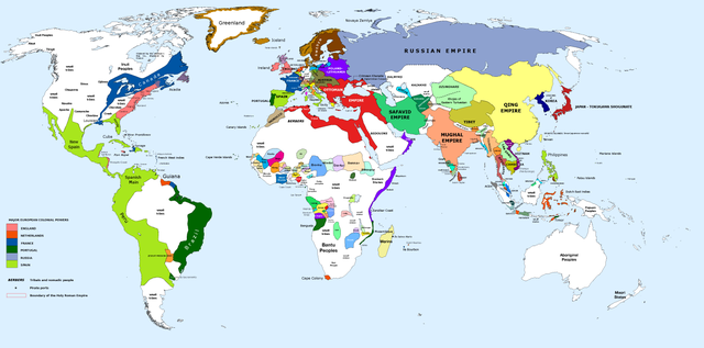
English: 1700 AD: An illustrative map of the world in the early colonial period. The Mughal Empire in India is at its greatest territorial extent. |
||
| ဝၼ်းထီႉ | |||
| ငိူၼ်ႈငဝ်ႈတိုၼ်း | Own work. Blank map from File:World_Map_Blank.svg. | ||
| ၽူႈတႅမ်ႈလိၵ်ႈ | Urnanabha | ||
| Other versions |
|

| Maps of world history | |
| BC | |
|
| |
| AD |
1 · 50 · 100 · 200 · 250 · 300 · 400 · 500 · 700 · 750 · 820 · 900 · 1200 · 1500 · 1556 · 1648 · 1700 · 1750 · 1815 · 1859 · 1871 · 1914 · 1935 · 1954 · 1989 · 2000 · |
|
Maps of colonization history | |
|
see also: Eastern Hemisphere only maps template (1300BC-1500AD) | |
| (this template: · view · discuss ) | |
.jpg)
._LOC_2001620596.jpg)
ဝ်ႂ
I, the copyright holder of this work, hereby publish it under the following license:
ၾၢႆႇဢၼ်ၼႆႉၼႆႉ မီးသုၼ်ႇဝႂ် ပႃႈတႂ်ႈ ၶွင် Creative Commons Attribution-Share Alike 3.0 Unported ဝႆႉၼႆႉ။
- ၸဝ်ႈၵဝ်ႇထၢင်ႇႁၢင်ႈ
- တႃႇၽႄၸႂ်ႉ – တွၼ်ႈတႃႇထုတ်ႇဢဝ်၊ ပိုၼ်ၽႄႈ လႄႈ ပိုၼ်ဢွၵ်ႇပၼ် ၼႃႈၵၢၼ်။
- ၶိုၼ်းထႅမ်သႂ်ႇ – မႄးထွင်ၵၢၼ် ႁႂ်ႈသၢင်ႇထုၵ်ႇ
- ၸွမ်းၼင်ႇ သၢႆႇငၢႆတီႈတႂ်ႈၼႆႉ
- ႁၢင်ႈၽၢင်ၶဝ်ႈပႃး – ၸဝ်ႈၵဝ်ႇတေလႆႈမွၵ်ႇပၼ်ၸိုဝ်ႈ ဢၼ်သၢင်ႇထုၵ်ႇ တွၼ်ႈတႃႇ ႁဵင်းၵွင်ႉ ဢၼ်ၵမ်ႉထႅမ်ပၼ် ဝႂ်ၶႂၢင်း လႄႈ သင်ၸိူဝ်ႉဝႃႈ လႆႈမီးလွင်ႈလႅၵ်ႈလၢႆႈမႃးၼႆ ၶႅၼ်းတေႃႈ ၸီႉၼႄပၼ်သေၵမ်း။ ၸဝ်ႈၵဝ်ထုၵ်ႇလီႁဵတ်း ႁႂ်ႈပဵၼ်တၢင်းႁဵတ်းသၢင်ႈ မီးလွင်ႈမီးတၢင်းမၼ်း၊ ၵူၺ်းၵႃႈဝႃႈ မၼ်းဢမ်ႇမၢႆထိုင်ဝႃႈ ဝႂ်ၶႂၢင်းၼၼ်ႉ မၼ်းတေပဵၼ် ဢၼ်ၸွႆႈဢၼ်ၵမ်ႉထႅမ်ပၼ် ၸဝ်ႈၵဝ်ႇ ဢမ်ႇၼၼ် ဢၼ်ၸဝ်ႈၵဝ်ႇၸႂ်ႉဝႆႉၼၼ်ႉ။
- သျေး ဢၼ်မိူၼ် – သင်ၸိူဝ်ႉဝႃႈ ၸဝ်ႈၵဝ်ႇ ၶိုၼ်းလေႃး၊ လႅၵ်ႈလၢႆႈ၊ မႄးၶိုၼ်း ဢမ်ႇၼၼ် ၵေႃႇသၢင်ႈ ၵႃႈတီႈၼိူဝ် ၼႃႈၵၢၼ်ၼႆႉၸိုင်၊ ၸဝ်ႈၵဝ်ႇ တေလႆႈဢဝ် လွင်ႈၸွႆႈသၢင်ႈၸဝ်ႈၵဝ်ႇၼႆႉ ပိုၼ်ၽႄႈ ၽၢႆႇတႂ်ႈ မိူၼ်ၼင်ႇ ဢမ်ႇၼၼ် ဝႂ်ငမ်ႇမႅၼ်ႈ ၼင်ႇ ငဝ်ႈတိုၼ်းမၼ်းၼၼ်ႉယဝ်ႉ။
ပိုၼ်းၾၢႆႇ
တဵၵ်းၼိူဝ် ဝၼ်းထိ/ၶၢဝ်းယၢမ်း တႃႇႁၼ်ၾၢႆႇ ၼႂ်းဝၼ်းၼၼ်ႉ
| ဝၼ်းထီႉ/ၶၢဝ်းယၢမ်း | ႁၢင်ႈလဵၵ်ႉ | သႅၼ်းမၼ်း | ၽူႈၸႂ်ႉတိုဝ်း | တၢင်းႁၼ်ထိုင် | |
|---|---|---|---|---|---|
| ယၢမ်းလဵဝ် | 10:00, 29 မၢတ်ႉၶျ် 2023 | | 4,500 × 2,234 (364 KB) | Yourlocallordandsavior | Slightly adjusted Mainland SE Asia borders. |
| 01:49, 28 ၾႅပ်ႇဝႃႇရီႇ 2019 |  | 4,500 × 2,234 (380 KB) | KnightxxArrow | Fixed inaccurate Cambodian border. | |
| 22:37, 4 ဢေႇပရႄႇ 2017 |  | 4,500 × 2,234 (401 KB) | Chamboz | Fixed wildly inaccurate Ottoman southern border. | |
| 00:10, 26 ၸၼ်ႇဝႃႇရီႇ 2014 |  | 4,500 × 2,234 (328 KB) | Ukabia | Added states | |
| 21:31, 24 ၸၼ်ႇဝႃႇရီႇ 2014 |  | 4,500 × 2,234 (38.36 MB) | Ukabia | Added African states | |
| 05:36, 13 ၸၼ်ႇဝႃႇရီႇ 2013 |  | 4,500 × 2,234 (325 KB) | Urnanabha | User created page with UploadWizard |
လွင်ႈၸႂ်ႉတိုဝ်း ၾၢႆႇ
ၼႃႈလိၵ်ႈ ၵွင်ႉမႃးၸူးၾၢႆႇၼႆႉ:
လွင်ႈၸႂ်ႉတိုဝ်းၾၢႆႇလူမ်ႈၽႃႉ
Wikis ၸိူဝ်းဢၼ်ၸႂ်ႉဝႆႉ ၾၢႆႇဢၼ်ၼႆႉ:
- ၸႂ်ႉဝႆႉ azb.wikipedia.org
- ၸႂ်ႉဝႆႉ bs.wikipedia.org
- ၸႂ်ႉဝႆႉ ce.wikipedia.org
- ၸႂ်ႉဝႆႉ de.wikipedia.org
- ၸႂ်ႉဝႆႉ en.wikipedia.org
- ၸႂ်ႉဝႆႉ eo.wikipedia.org
- ၸႂ်ႉဝႆႉ es.wikipedia.org
- ၸႂ်ႉဝႆႉ et.wikipedia.org
- ၸႂ်ႉဝႆႉ eu.wikipedia.org
- ၸႂ်ႉဝႆႉ fi.wikipedia.org
- ၸႂ်ႉဝႆႉ fr.wikipedia.org
- ၸႂ်ႉဝႆႉ gl.wikipedia.org
- ၸႂ်ႉဝႆႉ he.wikipedia.org
- ၸႂ်ႉဝႆႉ hy.wikipedia.org
- ၸႂ်ႉဝႆႉ id.wikipedia.org
- ၸႂ်ႉဝႆႉ io.wikipedia.org
- ၸႂ်ႉဝႆႉ it.wikipedia.org
- ၸႂ်ႉဝႆႉ it.wikiquote.org
- ၸႂ်ႉဝႆႉ ja.wikipedia.org
- ၸႂ်ႉဝႆႉ lv.wikipedia.org
- ၸႂ်ႉဝႆႉ my.wikipedia.org
- ၸႂ်ႉဝႆႉ pap.wikipedia.org
- ၸႂ်ႉဝႆႉ pnb.wikipedia.org
- ၸႂ်ႉဝႆႉ ro.wikipedia.org
- ၸႂ်ႉဝႆႉ ru.wikipedia.org
- ၸႂ်ႉဝႆႉ te.wikipedia.org
- ၸႂ်ႉဝႆႉ ur.wikipedia.org
- ၸႂ်ႉဝႆႉ vi.wikipedia.org