
ၾၢႆႇ:China 100.78713E 35.63718N.jpg

သႅၼ်းတႃႇတူၺ်းလူင်ႈၼႃႈ: 800 × 599 ၽိၵ်ႉသႄႇလ်. resolutionsတၢင်ႇဢၼ် : 320 × 240 ၽိၵ်ႉသႄႇလ် | 640 × 479 ၽိၵ်ႉသႄႇလ် | 1,024 × 766 ၽိၵ်ႉသႄႇလ် | 1,280 × 958 ၽိၵ်ႉသႄႇလ် ။
ၾၢႆႇငဝ်ႈတိုၼ်း (1,280 × 958 pixels, တၢင်းလဵၵ်ႉတၢင်းယႂ်ႇ ၾၢႆႇ: 226 KB, ယိူင်ႈ MIME: image/jpeg)
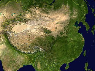
NASA World Wind screenshot.
| This image is in the public domain because it is a screenshot from NASA’s globe software World Wind using a public domain layer, such as Blue Marble, MODIS, Landsat, SRTM, USGS or GLOBE.
|
 |
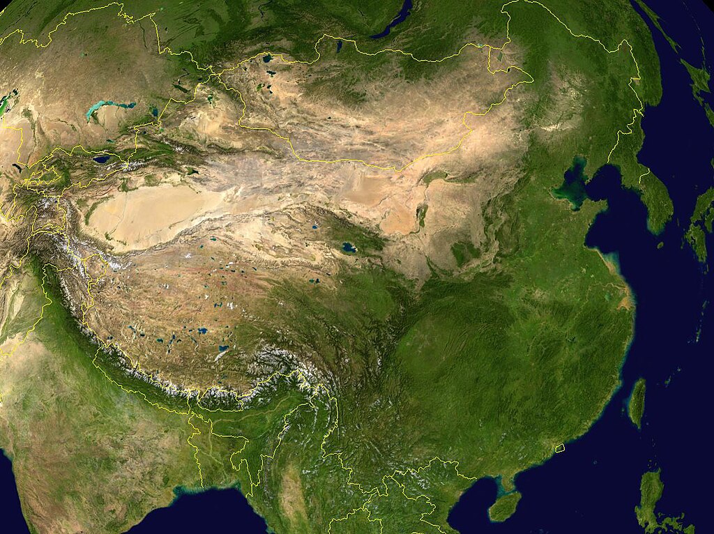
derivative works
Derivative works of this file: China 100.78713E 35.63718N-2010-23-08.jpg
.
ပိုၼ်းၾၢႆႇ
တဵၵ်းၼိူဝ် ဝၼ်းထိ/ၶၢဝ်းယၢမ်း တႃႇႁၼ်ၾၢႆႇ ၼႂ်းဝၼ်းၼၼ်ႉ
| ဝၼ်းထီႉ/ၶၢဝ်းယၢမ်း | ႁၢင်ႈလဵၵ်ႉ | သႅၼ်းမၼ်း | ၽူႈၸႂ်ႉတိုဝ်း | တၢင်းႁၼ်ထိုင် | |
|---|---|---|---|---|---|
| ယၢမ်းလဵဝ် | 11:28, 15 မေႇ 2005 | | 1,280 × 958 (226 KB) | Rex | NASA World Wind screenshot. {{PD-USGov-NASA}} Category:Maps of China |
လွင်ႈၸႂ်ႉတိုဝ်း ၾၢႆႇ
ဢမ်ႇမီးၼႃႈလိၵ်ႈဢၼ်ၵွင်ႉၸူး ၾၢႆႇဢၼ်ၼႆႉ
လွင်ႈၸႂ်ႉတိုဝ်းၾၢႆႇလူမ်ႈၽႃႉ
Wikis ၸိူဝ်းဢၼ်ၸႂ်ႉဝႆႉ ၾၢႆႇဢၼ်ၼႆႉ:
- ၸႂ်ႉဝႆႉ af.wikipedia.org
- ၸႂ်ႉဝႆႉ ang.wikipedia.org
- ၸႂ်ႉဝႆႉ an.wikipedia.org
- ၸႂ်ႉဝႆႉ ar.wikipedia.org
- ၸႂ်ႉဝႆႉ az.wikipedia.org
- ၸႂ်ႉဝႆႉ bm.wikipedia.org
- ၸႂ်ႉဝႆႉ bn.wikipedia.org
- ၸႂ်ႉဝႆႉ bo.wikipedia.org
- ၸႂ်ႉဝႆႉ bxr.wikipedia.org
- ၸႂ်ႉဝႆႉ ca.wikipedia.org
- ၸႂ်ႉဝႆႉ ca.wikibooks.org
- ၸႂ်ႉဝႆႉ cs.wikipedia.org
- ၸႂ်ႉဝႆႉ da.wikipedia.org
- ၸႂ်ႉဝႆႉ dz.wikipedia.org
- ၸႂ်ႉဝႆႉ el.wikipedia.org
- ၸႂ်ႉဝႆႉ en.wikipedia.org
- ၸႂ်ႉဝႆႉ eo.wikipedia.org
- ၸႂ်ႉဝႆႉ es.wikipedia.org
- ၸႂ်ႉဝႆႉ fa.wikipedia.org
- ၸႂ်ႉဝႆႉ fo.wikipedia.org
- ၸႂ်ႉဝႆႉ fr.wikipedia.org
- ၸႂ်ႉဝႆႉ gcr.wikipedia.org
- ၸႂ်ႉဝႆႉ gl.wikipedia.org
- ၸႂ်ႉဝႆႉ hi.wikipedia.org
- ၸႂ်ႉဝႆႉ hr.wikipedia.org
- ၸႂ်ႉဝႆႉ hu.wikipedia.org
- ၸႂ်ႉဝႆႉ hy.wikipedia.org
- ၸႂ်ႉဝႆႉ hyw.wikipedia.org
- ၸႂ်ႉဝႆႉ id.wikipedia.org
- ၸႂ်ႉဝႆႉ ig.wikipedia.org
- ၸႂ်ႉဝႆႉ incubator.wikimedia.org
- ၸႂ်ႉဝႆႉ io.wikipedia.org
- ၸႂ်ႉဝႆႉ it.wikipedia.org
တူၺ်း ၾၢႆႇmore global usage ဢၼ်ၼႆႉ