
ၾၢႆႇ:Topographic map of Saint Helena-en.svg

Size of this PNG preview of this SVG file: 740 × 600 ၽိၵ်ႉသႄႇလ်. resolutionsတၢင်ႇဢၼ် : 296 × 240 ၽိၵ်ႉသႄႇလ် | 592 × 480 ၽိၵ်ႉသႄႇလ် | 948 × 768 ၽိၵ်ႉသႄႇလ် | 1,264 × 1,024 ၽိၵ်ႉသႄႇလ် | 2,527 × 2,048 ၽိၵ်ႉသႄႇလ် | 802 × 650 ၽိၵ်ႉသႄႇလ် ။
ၾၢႆႇငဝ်ႈတိုၼ်း (ၾၢႆႇ SVG, ၸိုဝ်ႈ 802 × 650 pixels, သႅၼ်းၾၢႆႇ : 583 KB)
ႁူဝ်ႁုပ်ႈ
| ၶေႃႈသပ်းလႅင်း |
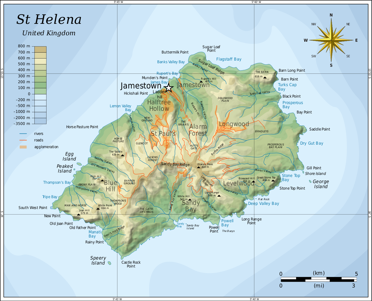
English: Topographic map of the British island of Saint Helena. |
| ဝၼ်းထီႉ | |
| ငိူၼ်ႈငဝ်ႈတိုၼ်း |
Self-made in Inkscape. Based on several sources:
|
| ၽူႈတႅမ်ႈလိၵ်ႈ | Oona Räisänen (Mysid) |
| Other versions |
Derivative works of this file: |

|
This SVG file contains embedded text that can be translated into your language, using any capable SVG editor, text editor or the SVG Translate tool. For more information see: About translating SVG files. |
ဝ်ႂ
I, the copyright holder of this work, hereby publish it under the following licenses:
ၾၢႆႇဢၼ်ၼႆႉၼႆႉ မီးသုၼ်ႇဝႂ် ပႃႈတႂ်ႈ ၶွင် Creative Commons Attribution-Share Alike 3.0 Unported ဝႆႉၼႆႉ။
- ၸဝ်ႈၵဝ်ႇထၢင်ႇႁၢင်ႈ
- တႃႇၽႄၸႂ်ႉ – တွၼ်ႈတႃႇထုတ်ႇဢဝ်၊ ပိုၼ်ၽႄႈ လႄႈ ပိုၼ်ဢွၵ်ႇပၼ် ၼႃႈၵၢၼ်။
- ၶိုၼ်းထႅမ်သႂ်ႇ – မႄးထွင်ၵၢၼ် ႁႂ်ႈသၢင်ႇထုၵ်ႇ
- ၸွမ်းၼင်ႇ သၢႆႇငၢႆတီႈတႂ်ႈၼႆႉ
- ႁၢင်ႈၽၢင်ၶဝ်ႈပႃး – ၸဝ်ႈၵဝ်ႇတေလႆႈမွၵ်ႇပၼ်ၸိုဝ်ႈ ဢၼ်သၢင်ႇထုၵ်ႇ တွၼ်ႈတႃႇ ႁဵင်းၵွင်ႉ ဢၼ်ၵမ်ႉထႅမ်ပၼ် ဝႂ်ၶႂၢင်း လႄႈ သင်ၸိူဝ်ႉဝႃႈ လႆႈမီးလွင်ႈလႅၵ်ႈလၢႆႈမႃးၼႆ ၶႅၼ်းတေႃႈ ၸီႉၼႄပၼ်သေၵမ်း။ ၸဝ်ႈၵဝ်ထုၵ်ႇလီႁဵတ်း ႁႂ်ႈပဵၼ်တၢင်းႁဵတ်းသၢင်ႈ မီးလွင်ႈမီးတၢင်းမၼ်း၊ ၵူၺ်းၵႃႈဝႃႈ မၼ်းဢမ်ႇမၢႆထိုင်ဝႃႈ ဝႂ်ၶႂၢင်းၼၼ်ႉ မၼ်းတေပဵၼ် ဢၼ်ၸွႆႈဢၼ်ၵမ်ႉထႅမ်ပၼ် ၸဝ်ႈၵဝ်ႇ ဢမ်ႇၼၼ် ဢၼ်ၸဝ်ႈၵဝ်ႇၸႂ်ႉဝႆႉၼၼ်ႉ။
- သျေး ဢၼ်မိူၼ် – သင်ၸိူဝ်ႉဝႃႈ ၸဝ်ႈၵဝ်ႇ ၶိုၼ်းလေႃး၊ လႅၵ်ႈလၢႆႈ၊ မႄးၶိုၼ်း ဢမ်ႇၼၼ် ၵေႃႇသၢင်ႈ ၵႃႈတီႈၼိူဝ် ၼႃႈၵၢၼ်ၼႆႉၸိုင်၊ ၸဝ်ႈၵဝ်ႇ တေလႆႈဢဝ် လွင်ႈၸွႆႈသၢင်ႈၸဝ်ႈၵဝ်ႇၼႆႉ ပိုၼ်ၽႄႈ ၽၢႆႇတႂ်ႈ မိူၼ်ၼင်ႇ ဢမ်ႇၼၼ် ဝႂ်ငမ်ႇမႅၼ်ႈ ၼင်ႇ ငဝ်ႈတိုၼ်းမၼ်းၼၼ်ႉယဝ်ႉ။

|
ပၼ်ၶႂၢင်ႉ တႃႇတေ ထုတ်ႇဢဝ်၊ ၽႄႈတိုၼ်း လႄႈ/ဢမ်ႇၼၼ် မႄးထတ်း ၼႂ်းလိၵ်ႈၼႆႉ ၸွမ်းၼင်ႇ ၶေႃႈမၼ်ႈၸႂ် GNU Free Documentation License, Version 1.2 ဢမ်ႇၼၼ် ၸိူဝ်းပဵၼ် မၢႆဢွၵ်ႇ ဢၼ်ထုၵ်ႇပိုၼ်ဢွၵ်ႇ ဝၢႆးလင် ၼင်ႇ Free Software Foundation; ဢၼ်ဢမ်ႇမီး လွင်ႈလႅၵ်ႈလၢႆႈ ၵႃႈတီႈ တွၼ်ႈၵၼ်၊ လိၵ်ႈၸိူဝ်းမီးတီႈ ၼႃႈသိုဝ်ႈၽၢႆႈၼႃႈ၊ ၼႃႈသိုဝ်ႈၽၢႆႇလင်။ဢၼ်ပဵၼ် ဝႂ်တႃႇထုတ်ႇဢဝ်ၼႆႉ မၼ်းတေၶဝ်ႈပႃးဝႆႉ ၵႃႈတီႈ တွၼ်ႈၵၼ် ဢၼ်မီးႁူဝ်ၶေႃႈဝႃႈ GNU Free Documentation License ၼၼ်ႉ။ |
ၸဝ်ႈၵဝ်ႇထုၵ်ႇလိူၵ်ႈ ဝႆတွၼ်ႈတႃႇ ဢၼ်ၸဝ်ႈၵဝ်ႇလိူၵ်ႈၼၼ်ႉ
ပိုၼ်းၾၢႆႇ
တဵၵ်းၼိူဝ် ဝၼ်းထိ/ၶၢဝ်းယၢမ်း တႃႇႁၼ်ၾၢႆႇ ၼႂ်းဝၼ်းၼၼ်ႉ
| ဝၼ်းထီႉ/ၶၢဝ်းယၢမ်း | ႁၢင်ႈလဵၵ်ႉ | သႅၼ်းမၼ်း | ၽူႈၸႂ်ႉတိုဝ်း | တၢင်းႁၼ်ထိုင် | |
|---|---|---|---|---|---|
| ယၢမ်းလဵဝ် | 05:54, 10 ဢေႃးၵၢတ်ႉ 2010 | | 802 × 650 (583 KB) | Mysid | legend for roads, rivers, agglomeration |
| 21:42, 9 ဢေႃးၵၢတ်ႉ 2010 |  | 802 × 650 (580 KB) | Mysid | bugfix #2 | |
| 21:40, 9 ဢေႃးၵၢတ်ႉ 2010 |  | 802 × 650 (260 KB) | Mysid | bugfix | |
| 21:27, 9 ဢေႃးၵၢတ်ႉ 2010 |  | 647 × 594 (579 KB) | Mysid | {{Information |Description={{en|1=Topographic map of the British island of w:Saint Helena.}} |Source=Self-made in Inkscape. Based on several sources. |Author=Mysid |Date=2010-08-10 |Permission= |other_versions= }} {{translation possi |
လွင်ႈၸႂ်ႉတိုဝ်း ၾၢႆႇ
ၼႃႈလိၵ်ႈ ၵွင်ႉမႃးၸူးၾၢႆႇၼႆႉ:
လွင်ႈၸႂ်ႉတိုဝ်းၾၢႆႇလူမ်ႈၽႃႉ
Wikis ၸိူဝ်းဢၼ်ၸႂ်ႉဝႆႉ ၾၢႆႇဢၼ်ၼႆႉ:
- ၸႂ်ႉဝႆႉ af.wikipedia.org
- ၸႂ်ႉဝႆႉ als.wikipedia.org
- ၸႂ်ႉဝႆႉ ar.wikipedia.org
- ၸႂ်ႉဝႆႉ arz.wikipedia.org
- ၸႂ်ႉဝႆႉ ast.wikipedia.org
- ၸႂ်ႉဝႆႉ bg.wikipedia.org
- ၸႂ်ႉဝႆႉ bn.wikipedia.org
- ၸႂ်ႉဝႆႉ bs.wikipedia.org
- ၸႂ်ႉဝႆႉ ca.wikipedia.org
- ၸႂ်ႉဝႆႉ ckb.wikipedia.org
- ၸႂ်ႉဝႆႉ da.wikipedia.org
- ၸႂ်ႉဝႆႉ el.wikipedia.org
- ၸႂ်ႉဝႆႉ en.wikipedia.org
- ၸႂ်ႉဝႆႉ eo.wikipedia.org
- ၸႂ်ႉဝႆႉ es.wikipedia.org
- ၸႂ်ႉဝႆႉ eu.wikipedia.org
- ၸႂ်ႉဝႆႉ fa.wikipedia.org
- ၸႂ်ႉဝႆႉ fi.wikipedia.org
- ၸႂ်ႉဝႆႉ fy.wikipedia.org
- ၸႂ်ႉဝႆႉ ga.wikipedia.org
- ၸႂ်ႉဝႆႉ gl.wikipedia.org
- ၸႂ်ႉဝႆႉ gv.wikipedia.org
- ၸႂ်ႉဝႆႉ he.wikipedia.org
- ၸႂ်ႉဝႆႉ hr.wikipedia.org
- ၸႂ်ႉဝႆႉ hu.wikipedia.org
- ၸႂ်ႉဝႆႉ hy.wikipedia.org
- ၸႂ်ႉဝႆႉ ie.wikipedia.org
- ၸႂ်ႉဝႆႉ io.wikipedia.org
- ၸႂ်ႉဝႆႉ it.wikipedia.org
တူၺ်း ၾၢႆႇmore global usage ဢၼ်ၼႆႉ