
ၾၢႆႇ:Australia South Australia location map.svg

ၾၢႆႇငဝ်ႈတိုၼ်း (ၾၢႆႇ SVG, ၸိုဝ်ႈ 1,535 × 1,783 pixels, သႅၼ်းၾၢႆႇ : 367 KB)
ႁူဝ်ႁုပ်ႈ
| ၶေႃႈသပ်းလႅင်း |
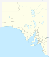
Quadratische Plattkarte, N-S-Streckung 117 %. Geographische Begrenzung der Karte:
Equirectangular projection, N/S stretching 117 %. Geographic limits of the map:
|
|
| ဝၼ်းထီႉ | ||
| ငိူၼ်ႈငဝ်ႈတိုၼ်း |
ၵၢၼ်ၶွင်တူဝ်, using
|
|
| ၽူႈတႅမ်ႈလိၵ်ႈ | NordNordWest | |
| ၶေႃႈလူတ်းပွႆႇ (ၶိုၼ်းၸႂ်ႉ ၾၢႆႇဢၼ်ၼႆႉ) |
This file is licensed under the Creative Commons Attribution-Share Alike 3.0 Germany license.
 This file is licensed under the Creative Commons Attribution-Share Alike 3.0 Germany license.
|


|
This map has been made or improved in the German Kartenwerkstatt (Map Lab). You can propose maps to improve as well.
|
ပိုၼ်းၾၢႆႇ
တဵၵ်းၼိူဝ် ဝၼ်းထိ/ၶၢဝ်းယၢမ်း တႃႇႁၼ်ၾၢႆႇ ၼႂ်းဝၼ်းၼၼ်ႉ
| ဝၼ်းထီႉ/ၶၢဝ်းယၢမ်း | ႁၢင်ႈလဵၵ်ႉ | သႅၼ်းမၼ်း | ၽူႈၸႂ်ႉတိုဝ်း | တၢင်းႁၼ်ထိုင် | |
|---|---|---|---|---|---|
| ယၢမ်းလဵဝ် | 22:08, 4 ဢေႇပရႄႇ 2010 | | 1,535 × 1,783 (367 KB) | Chumwa | Reverted to version as of 20:05, 29 December 2009 |
| 21:54, 4 ဢေႇပရႄႇ 2010 |  | 1,535 × 1,783 (316 KB) | Roke~commonswiki | local government low salience, dont appear on general use maps | |
| 20:05, 29 တီႇသႅမ်ႇပႃႇ 2009 |  | 1,535 × 1,783 (367 KB) | NordNordWest | =={{int:filedesc}}== {{Information |Description= {{de|Positionskarte von South Australia, Australien}} Quadratische Plattkarte, N-S-Streckung 117 %. Geographische Begrenzung der Karte: * N: 25.6° S * S: 38.5° S |
လွင်ႈၸႂ်ႉတိုဝ်း ၾၢႆႇ
2 ၼႃႈလိၵ်ႈ ၵွင်ႉမႃးၸူးၾၢႆႇၼႆႉ:
လွင်ႈၸႂ်ႉတိုဝ်းၾၢႆႇလူမ်ႈၽႃႉ
Wikis ၸိူဝ်းဢၼ်ၸႂ်ႉဝႆႉ ၾၢႆႇဢၼ်ၼႆႉ:
- ၸႂ်ႉဝႆႉ af.wikipedia.org
- ၸႂ်ႉဝႆႉ ar.wikipedia.org
- ၸႂ်ႉဝႆႉ ast.wikipedia.org
- ၸႂ်ႉဝႆႉ azb.wikipedia.org
- ၸႂ်ႉဝႆႉ ba.wikipedia.org
- ၸႂ်ႉဝႆႉ be.wikipedia.org
- ၸႂ်ႉဝႆႉ bg.wikipedia.org
- ၸႂ်ႉဝႆႉ ceb.wikipedia.org
- ၸႂ်ႉဝႆႉ de.wikipedia.org
- Adelaide
- Coober Pedy
- Klemzig
- Woomera (Australien)
- Riverland
- Goodwood (South Australia)
- Keith (Australien)
- Hahndorf (South Australia)
- Waterfall Gully
- Maralinga
- Renmark
- Naracoorte
- William Creek
- Aldgate (South Australia)
- Mount Gambier
- Murray Bridge
- Port Augusta
- Port Pirie
- Port Lincoln
- Victor Harbor
- Whyalla
- Anna Creek Station
- Tarcoola
- Melrose (South Australia)
- Cook (South Australia)
- Vorlage:Positionskarte Australien Südaustralien
- Lobethal
- Ooldea
- Flughafen Port Augusta
- Flugplatz Coober Pedy
- Angaston
- Mungeranie
- Wikipedia:Kartenwerkstatt/Positionskarten/Australien und Ozeanien
- Burra (Australien)
တူၺ်း ၾၢႆႇmore global usage ဢၼ်ၼႆႉ