
ၾၢႆႇ:Australia Victoria location map highways.svg

Size of this PNG preview of this SVG file: 800 × 563 ၽိၵ်ႉသႄႇလ်. resolutionsတၢင်ႇဢၼ် : 320 × 225 ၽိၵ်ႉသႄႇလ် | 640 × 450 ၽိၵ်ႉသႄႇလ် | 1,024 × 720 ၽိၵ်ႉသႄႇလ် | 1,280 × 900 ၽိၵ်ႉသႄႇလ် | 2,560 × 1,800 ၽိၵ်ႉသႄႇလ် | 1,375 × 967 ၽိၵ်ႉသႄႇလ် ။
ၾၢႆႇငဝ်ႈတိုၼ်း (ၾၢႆႇ SVG, ၸိုဝ်ႈ 1,375 × 967 pixels, သႅၼ်းၾၢႆႇ : 729 KB)
| ၶေႃႈသပ်းလႅင်း |
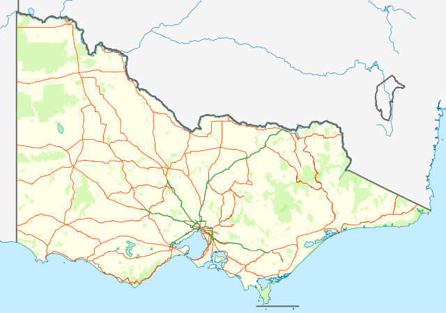
English: Location map with highways (in Orange) and freeways (in Green) of Victoria, Australia. Also shows state forests and national parks.
Equirectangular projection, N/S stretching 124 %. Geographic limits of the map:
Deutsch: Positionskarte mit Highways (Straße zwischen Großstädte; in Orange) and Freeways (~Autobahnen; in Grün) von Victoria, Australien. Auch mit Nationalparks
Quadratische Plattkarte, N-S-Streckung 124 %. Geographische Begrenzung der Karte:
|
| ဝၼ်းထီႉ | (UTC) |
| ငိူၼ်ႈငဝ်ႈတိုၼ်း | |
| ၽူႈတႅမ်ႈလိၵ်ႈ |
|
| This is a retouched picture, which means that it has been digitally altered from its original version. Modifications: show roads and national parks. The original can be viewed here: Australia Victoria location map blank.svg:
|
I, the copyright holder of this work, hereby publish it under the following license:
ၾၢႆႇဢၼ်ၼႆႉၼႆႉ မီးသုၼ်ႇဝႂ် ပႃႈတႂ်ႈ ၶွင် Creative Commons Attribution-Share Alike 3.0 Unported ဝႆႉၼႆႉ။
- ၸဝ်ႈၵဝ်ႇထၢင်ႇႁၢင်ႈ
- တႃႇၽႄၸႂ်ႉ – တွၼ်ႈတႃႇထုတ်ႇဢဝ်၊ ပိုၼ်ၽႄႈ လႄႈ ပိုၼ်ဢွၵ်ႇပၼ် ၼႃႈၵၢၼ်။
- ၶိုၼ်းထႅမ်သႂ်ႇ – မႄးထွင်ၵၢၼ် ႁႂ်ႈသၢင်ႇထုၵ်ႇ
- ၸွမ်းၼင်ႇ သၢႆႇငၢႆတီႈတႂ်ႈၼႆႉ
- ႁၢင်ႈၽၢင်ၶဝ်ႈပႃး – ၸဝ်ႈၵဝ်ႇတေလႆႈမွၵ်ႇပၼ်ၸိုဝ်ႈ ဢၼ်သၢင်ႇထုၵ်ႇ တွၼ်ႈတႃႇ ႁဵင်းၵွင်ႉ ဢၼ်ၵမ်ႉထႅမ်ပၼ် ဝႂ်ၶႂၢင်း လႄႈ သင်ၸိူဝ်ႉဝႃႈ လႆႈမီးလွင်ႈလႅၵ်ႈလၢႆႈမႃးၼႆ ၶႅၼ်းတေႃႈ ၸီႉၼႄပၼ်သေၵမ်း။ ၸဝ်ႈၵဝ်ထုၵ်ႇလီႁဵတ်း ႁႂ်ႈပဵၼ်တၢင်းႁဵတ်းသၢင်ႈ မီးလွင်ႈမီးတၢင်းမၼ်း၊ ၵူၺ်းၵႃႈဝႃႈ မၼ်းဢမ်ႇမၢႆထိုင်ဝႃႈ ဝႂ်ၶႂၢင်းၼၼ်ႉ မၼ်းတေပဵၼ် ဢၼ်ၸွႆႈဢၼ်ၵမ်ႉထႅမ်ပၼ် ၸဝ်ႈၵဝ်ႇ ဢမ်ႇၼၼ် ဢၼ်ၸဝ်ႈၵဝ်ႇၸႂ်ႉဝႆႉၼၼ်ႉ။
- သျေး ဢၼ်မိူၼ် – သင်ၸိူဝ်ႉဝႃႈ ၸဝ်ႈၵဝ်ႇ ၶိုၼ်းလေႃး၊ လႅၵ်ႈလၢႆႈ၊ မႄးၶိုၼ်း ဢမ်ႇၼၼ် ၵေႃႇသၢင်ႈ ၵႃႈတီႈၼိူဝ် ၼႃႈၵၢၼ်ၼႆႉၸိုင်၊ ၸဝ်ႈၵဝ်ႇ တေလႆႈဢဝ် လွင်ႈၸွႆႈသၢင်ႈၸဝ်ႈၵဝ်ႇၼႆႉ ပိုၼ်ၽႄႈ ၽၢႆႇတႂ်ႈ မိူၼ်ၼင်ႇ ဢမ်ႇၼၼ် ဝႂ်ငမ်ႇမႅၼ်ႈ ၼင်ႇ ငဝ်ႈတိုၼ်းမၼ်းၼၼ်ႉယဝ်ႉ။
Original upload log
This image is a derivative work of the following images:
- File:Australia_Victoria_location_map_blank.svg licensed with Cc-by-sa-3.0
- 2010-04-10T01:20:08Z Roke 1375x967 (279504 Bytes) {{Information |Description={{de|Positionskarte von [[:de:Victoria (Australien)|Victoria]], [[:de:Australien|Australien]]}} Quadratische Plattkarte, N-S-Streckung 124 %. Geographische Begrenzung der Karte: * N: 33.8° S * S: 3
Uploaded with derivativeFX
ပိုၼ်းၾၢႆႇ
တဵၵ်းၼိူဝ် ဝၼ်းထိ/ၶၢဝ်းယၢမ်း တႃႇႁၼ်ၾၢႆႇ ၼႂ်းဝၼ်းၼၼ်ႉ
| ဝၼ်းထီႉ/ၶၢဝ်းယၢမ်း | ႁၢင်ႈလဵၵ်ႉ | သႅၼ်းမၼ်း | ၽူႈၸႂ်ႉတိုဝ်း | တၢင်းႁၼ်ထိုင် | |
|---|---|---|---|---|---|
| ယၢမ်းလဵဝ် | 13:58, 25 ၾႅပ်ႇဝႃႇရီႇ 2011 | | 1,375 × 967 (729 KB) | Cassowary | {{Information |Description={{en|Location map with highways (in Orange) and freeways (in Green) of Victoria, Australia. Also shows state forests and national parks.}} Equirectangular projection, N/S stretchi |
လွင်ႈၸႂ်ႉတိုဝ်း ၾၢႆႇ
2 ၼႃႈလိၵ်ႈ ၵွင်ႉမႃးၸူးၾၢႆႇၼႆႉ:
လွင်ႈၸႂ်ႉတိုဝ်းၾၢႆႇလူမ်ႈၽႃႉ
Wikis ၸိူဝ်းဢၼ်ၸႂ်ႉဝႆႉ ၾၢႆႇဢၼ်ၼႆႉ:
- ၸႂ်ႉဝႆႉ bs.wikipedia.org
- ၸႂ်ႉဝႆႉ ceb.wikipedia.org
- ၸႂ်ႉဝႆႉ en.wikipedia.org
- ၸႂ်ႉဝႆႉ es.wikipedia.org
- ၸႂ်ႉဝႆႉ fa.wikipedia.org
- ၸႂ်ႉဝႆႉ kn.wikipedia.org
- ၸႂ်ႉဝႆႉ pl.wikipedia.org
- ၸႂ်ႉဝႆႉ pl.wikibooks.org
- ၸႂ်ႉဝႆႉ simple.wikipedia.org
- ၸႂ်ႉဝႆႉ si.wikipedia.org
- ၸႂ်ႉဝႆႉ sl.wikipedia.org
- ၸႂ်ႉဝႆႉ tr.wikipedia.org
- ၸႂ်ႉဝႆႉ uz.wikipedia.org
- ၸႂ်ႉဝႆႉ war.wikipedia.org