
ၾၢႆႇ:Ile-de-France region relief location map.jpg

သႅၼ်းတႃႇတူၺ်းလူင်ႈၼႃႈ: 742 × 600 ၽိၵ်ႉသႄႇလ်. resolutionsတၢင်ႇဢၼ် : 297 × 240 ၽိၵ်ႉသႄႇလ် | 594 × 480 ၽိၵ်ႉသႄႇလ် | 951 × 768 ၽိၵ်ႉသႄႇလ် | 1,267 × 1,024 ၽိၵ်ႉသႄႇလ် | 1,651 × 1,334 ၽိၵ်ႉသႄႇလ် ။
ၾၢႆႇငဝ်ႈတိုၼ်း (1,651 × 1,334 pixels, တၢင်းလဵၵ်ႉတၢင်းယႂ်ႇ ၾၢႆႇ: 552 KB, ယိူင်ႈ MIME: image/jpeg)
ႁူဝ်ႁုပ်ႈ
| Camera location | | View this and other nearby images on: OpenStreetMap |
|---|
| ၶေႃႈသပ်းလႅင်း |
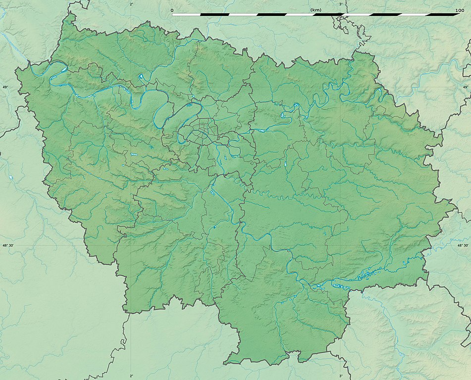
English: Blank physical map of the region of Île-de-France, France, as in January 2015, for geo-location purpose, with distinct boundaries for regions, departments and arrondissements.
Français : Carte physique vierge de la région Île-de-France, France, telle qu'en janvier 2015, destinée à la géolocalisation, avec limite distincte des régions, départements et arrondissements. Scale:
Equirectangular projection, WGS84 datum
Geographic limits of the map:
|
||
| ဝၼ်းထီႉ | |||
| ငိူၼ်ႈငဝ်ႈတိုၼ်း |
ၵၢၼ်ၶွင်တူဝ်
|
||
| ၽူႈတႅမ်ႈလိၵ်ႈ | Eric Gaba (Sting - fr:Sting) | ||
| ၶေႃႈလူတ်းပွႆႇ (ၶိုၼ်းၸႂ်ႉ ၾၢႆႇဢၼ်ၼႆႉ) |
|
||
| Other versions |
|

ဝ်ႂ
Eric Gaba, Wikimedia Commons user Sting, the copyright holder of this work, hereby publishes it under the following license:
ၾၢႆႇဢၼ်ၼႆႉၼႆႉ မီးသုၼ်ႇဝႂ် ပႃႈတႂ်ႈ ၶွင် Creative Commons Attribution-Share Alike 3.0 Unported ဝႆႉၼႆႉ။
ႁၢင်ႈၽၢင်: Eric Gaba, Wikimedia Commons user Sting
- ၸဝ်ႈၵဝ်ႇထၢင်ႇႁၢင်ႈ
- တႃႇၽႄၸႂ်ႉ – တွၼ်ႈတႃႇထုတ်ႇဢဝ်၊ ပိုၼ်ၽႄႈ လႄႈ ပိုၼ်ဢွၵ်ႇပၼ် ၼႃႈၵၢၼ်။
- ၶိုၼ်းထႅမ်သႂ်ႇ – မႄးထွင်ၵၢၼ် ႁႂ်ႈသၢင်ႇထုၵ်ႇ
- ၸွမ်းၼင်ႇ သၢႆႇငၢႆတီႈတႂ်ႈၼႆႉ
- ႁၢင်ႈၽၢင်ၶဝ်ႈပႃး – ၸဝ်ႈၵဝ်ႇတေလႆႈမွၵ်ႇပၼ်ၸိုဝ်ႈ ဢၼ်သၢင်ႇထုၵ်ႇ တွၼ်ႈတႃႇ ႁဵင်းၵွင်ႉ ဢၼ်ၵမ်ႉထႅမ်ပၼ် ဝႂ်ၶႂၢင်း လႄႈ သင်ၸိူဝ်ႉဝႃႈ လႆႈမီးလွင်ႈလႅၵ်ႈလၢႆႈမႃးၼႆ ၶႅၼ်းတေႃႈ ၸီႉၼႄပၼ်သေၵမ်း။ ၸဝ်ႈၵဝ်ထုၵ်ႇလီႁဵတ်း ႁႂ်ႈပဵၼ်တၢင်းႁဵတ်းသၢင်ႈ မီးလွင်ႈမီးတၢင်းမၼ်း၊ ၵူၺ်းၵႃႈဝႃႈ မၼ်းဢမ်ႇမၢႆထိုင်ဝႃႈ ဝႂ်ၶႂၢင်းၼၼ်ႉ မၼ်းတေပဵၼ် ဢၼ်ၸွႆႈဢၼ်ၵမ်ႉထႅမ်ပၼ် ၸဝ်ႈၵဝ်ႇ ဢမ်ႇၼၼ် ဢၼ်ၸဝ်ႈၵဝ်ႇၸႂ်ႉဝႆႉၼၼ်ႉ။
- သျေး ဢၼ်မိူၼ် – သင်ၸိူဝ်ႉဝႃႈ ၸဝ်ႈၵဝ်ႇ ၶိုၼ်းလေႃး၊ လႅၵ်ႈလၢႆႈ၊ မႄးၶိုၼ်း ဢမ်ႇၼၼ် ၵေႃႇသၢင်ႈ ၵႃႈတီႈၼိူဝ် ၼႃႈၵၢၼ်ၼႆႉၸိုင်၊ ၸဝ်ႈၵဝ်ႇ တေလႆႈဢဝ် လွင်ႈၸွႆႈသၢင်ႈၸဝ်ႈၵဝ်ႇၼႆႉ ပိုၼ်ၽႄႈ ၽၢႆႇတႂ်ႈ မိူၼ်ၼင်ႇ ဢမ်ႇၼၼ် ဝႂ်ငမ်ႇမႅၼ်ႈ ၼင်ႇ ငဝ်ႈတိုၼ်းမၼ်းၼၼ်ႉယဝ်ႉ။
ပိုၼ်းၾၢႆႇ
တဵၵ်းၼိူဝ် ဝၼ်းထိ/ၶၢဝ်းယၢမ်း တႃႇႁၼ်ၾၢႆႇ ၼႂ်းဝၼ်းၼၼ်ႉ
| ဝၼ်းထီႉ/ၶၢဝ်းယၢမ်း | ႁၢင်ႈလဵၵ်ႉ | သႅၼ်းမၼ်း | ၽူႈၸႂ်ႉတိုဝ်း | တၢင်းႁၼ်ထိုင် | |
|---|---|---|---|---|---|
| ယၢမ်းလဵဝ် | 15:32, 12 ၾႅပ်ႇဝႃႇရီႇ 2015 | | 1,651 × 1,334 (552 KB) | Sting | Color profile |
| 15:21, 12 ၾႅပ်ႇဝႃႇရီႇ 2015 |  | 1,651 × 1,334 (537 KB) | Sting | Boundaries correction | |
| 16:26, 22 ၸၼ်ႇဝႃႇရီႇ 2015 |  | 1,651 × 1,334 (605 KB) | Sting | Boundaries correction | |
| 13:57, 21 ၸၼ်ႇဝႃႇရီႇ 2015 |  | 1,651 × 1,334 (598 KB) | Sting | == {{int:filedesc}} == {{Location|48|40|30|N|02|30|00|E|scale:1000000}} {{Information |Description={{en|Blank physical map of the region of Île-de-France, France, as in January 2015, for geo-location purpose, with distinct bound... |
လွင်ႈၸႂ်ႉတိုဝ်း ၾၢႆႇ
2 ၼႃႈလိၵ်ႈ ၵွင်ႉမႃးၸူးၾၢႆႇၼႆႉ:
လွင်ႈၸႂ်ႉတိုဝ်းၾၢႆႇလူမ်ႈၽႃႉ
Wikis ၸိူဝ်းဢၼ်ၸႂ်ႉဝႆႉ ၾၢႆႇဢၼ်ၼႆႉ:
- ၸႂ်ႉဝႆႉ als.wikipedia.org
- ၸႂ်ႉဝႆႉ ast.wikipedia.org
- ၸႂ်ႉဝႆႉ ban.wikipedia.org
- ၸႂ်ႉဝႆႉ bg.wikipedia.org
- Париж
- Версай
- Курбьовоа
- Ньой сюр Сен
- Сюрен
- Булон Биянкур
- Со
- Аниер сюр Сен
- Бобини
- Мол (Франция)
- Самоа сюр Сен
- Аржантьой
- Фонтенбло
- Епине сюр Сен
- Вил д'Авре
- Сен Жермен ан Ле
- Сен Дени
- Иври сюр Сен
- Екол политекник
- Вилжуиф
- Монтрьой
- Нантер
- Кретей
- Олне су Боа
- Витри сюр Сен
- Коломб
- Шампини сюр Марн
- Рюей Малмезон
- Сен Мор де Фосе
- Шаблон:ПК Франция Ил дьо Франс
- Жоанвил льо Пон
- Монфермей
- Есман
- Етамп
- Удан
- Мелюн
- Аверн
- Барбизон
- Обержанвил
- Епон
- Монтро Фот Йон
- Маси
- Монжерон
- Сен Морис (Ил дьо Франс)
- Армантиер ан Бри
- Мо
တူၺ်း ၾၢႆႇmore global usage ဢၼ်ၼႆႉ