
ၾၢႆႇ:Scotland relief location map.jpg

သႅၼ်းတႃႇတူၺ်းလူင်ႈၼႃႈ: 456 × 600 ၽိၵ်ႉသႄႇလ်. resolutionsတၢင်ႇဢၼ် : 182 × 240 ၽိၵ်ႉသႄႇလ် | 365 × 480 ၽိၵ်ႉသႄႇလ် | 584 × 768 ၽိၵ်ႉသႄႇလ် | 1,128 × 1,483 ၽိၵ်ႉသႄႇလ် ။
ၾၢႆႇငဝ်ႈတိုၼ်း (1,128 × 1,483 pixels, တၢင်းလဵၵ်ႉတၢင်းယႂ်ႇ ၾၢႆႇ: 927 KB, ယိူင်ႈ MIME: image/jpeg)
ႁူဝ်ႁုပ်ႈ
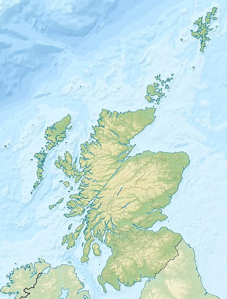
| ၶေႃႈသပ်းလႅင်း | Quadratische Plattkarte, N-S-Streckung 170 %. Geographische Begrenzung der Karte: * N: 61.0° N * S: 54.5° N * W: 8.8° W * O: 0.4° W Equirectangular projection, N/S stretching 170 %. Geographic limits of the map: * N: 61.0° N * S: 54.5° N * W: 8.8° W * E: 0.4° W |
| ဝၼ်းထီႉ | (UTC) |
| ငိူၼ်ႈငဝ်ႈတိုၼ်း | ၵၢၼ်ၶွင်တူဝ် |
| ၽူႈတႅမ်ႈလိၵ်ႈ |
|
| Other versions |
|

ဝ်ႂ
I, the copyright holder of this work, hereby publish it under the following licenses:
ၾၢႆႇဢၼ်ၼႆႉၼႆႉ မီးသုၼ်ႇဝႂ် ပႃႈတႂ်ႈ ၶွင် Creative Commons Attribution-Share Alike 3.0 Unported ဝႆႉၼႆႉ။
ႁၢင်ႈၽၢင်: Eric Gaba, NordNordWest, Uwe Dedering
- ၸဝ်ႈၵဝ်ႇထၢင်ႇႁၢင်ႈ
- တႃႇၽႄၸႂ်ႉ – တွၼ်ႈတႃႇထုတ်ႇဢဝ်၊ ပိုၼ်ၽႄႈ လႄႈ ပိုၼ်ဢွၵ်ႇပၼ် ၼႃႈၵၢၼ်။
- ၶိုၼ်းထႅမ်သႂ်ႇ – မႄးထွင်ၵၢၼ် ႁႂ်ႈသၢင်ႇထုၵ်ႇ
- ၸွမ်းၼင်ႇ သၢႆႇငၢႆတီႈတႂ်ႈၼႆႉ
- ႁၢင်ႈၽၢင်ၶဝ်ႈပႃး – ၸဝ်ႈၵဝ်ႇတေလႆႈမွၵ်ႇပၼ်ၸိုဝ်ႈ ဢၼ်သၢင်ႇထုၵ်ႇ တွၼ်ႈတႃႇ ႁဵင်းၵွင်ႉ ဢၼ်ၵမ်ႉထႅမ်ပၼ် ဝႂ်ၶႂၢင်း လႄႈ သင်ၸိူဝ်ႉဝႃႈ လႆႈမီးလွင်ႈလႅၵ်ႈလၢႆႈမႃးၼႆ ၶႅၼ်းတေႃႈ ၸီႉၼႄပၼ်သေၵမ်း။ ၸဝ်ႈၵဝ်ထုၵ်ႇလီႁဵတ်း ႁႂ်ႈပဵၼ်တၢင်းႁဵတ်းသၢင်ႈ မီးလွင်ႈမီးတၢင်းမၼ်း၊ ၵူၺ်းၵႃႈဝႃႈ မၼ်းဢမ်ႇမၢႆထိုင်ဝႃႈ ဝႂ်ၶႂၢင်းၼၼ်ႉ မၼ်းတေပဵၼ် ဢၼ်ၸွႆႈဢၼ်ၵမ်ႉထႅမ်ပၼ် ၸဝ်ႈၵဝ်ႇ ဢမ်ႇၼၼ် ဢၼ်ၸဝ်ႈၵဝ်ႇၸႂ်ႉဝႆႉၼၼ်ႉ။
- သျေး ဢၼ်မိူၼ် – သင်ၸိူဝ်ႉဝႃႈ ၸဝ်ႈၵဝ်ႇ ၶိုၼ်းလေႃး၊ လႅၵ်ႈလၢႆႈ၊ မႄးၶိုၼ်း ဢမ်ႇၼၼ် ၵေႃႇသၢင်ႈ ၵႃႈတီႈၼိူဝ် ၼႃႈၵၢၼ်ၼႆႉၸိုင်၊ ၸဝ်ႈၵဝ်ႇ တေလႆႈဢဝ် လွင်ႈၸွႆႈသၢင်ႈၸဝ်ႈၵဝ်ႇၼႆႉ ပိုၼ်ၽႄႈ ၽၢႆႇတႂ်ႈ မိူၼ်ၼင်ႇ ဢမ်ႇၼၼ် ဝႂ်ငမ်ႇမႅၼ်ႈ ၼင်ႇ ငဝ်ႈတိုၼ်းမၼ်းၼၼ်ႉယဝ်ႉ။

|
ပၼ်ၶႂၢင်ႉ တႃႇတေ ထုတ်ႇဢဝ်၊ ၽႄႈတိုၼ်း လႄႈ/ဢမ်ႇၼၼ် မႄးထတ်း ၼႂ်းလိၵ်ႈၼႆႉ ၸွမ်းၼင်ႇ ၶေႃႈမၼ်ႈၸႂ် GNU Free Documentation License, Version 1.2 ဢမ်ႇၼၼ် ၸိူဝ်းပဵၼ် မၢႆဢွၵ်ႇ ဢၼ်ထုၵ်ႇပိုၼ်ဢွၵ်ႇ ဝၢႆးလင် ၼင်ႇ Free Software Foundation; ဢၼ်ဢမ်ႇမီး လွင်ႈလႅၵ်ႈလၢႆႈ ၵႃႈတီႈ တွၼ်ႈၵၼ်၊ လိၵ်ႈၸိူဝ်းမီးတီႈ ၼႃႈသိုဝ်ႈၽၢႆႈၼႃႈ၊ ၼႃႈသိုဝ်ႈၽၢႆႇလင်။ဢၼ်ပဵၼ် ဝႂ်တႃႇထုတ်ႇဢဝ်ၼႆႉ မၼ်းတေၶဝ်ႈပႃးဝႆႉ ၵႃႈတီႈ တွၼ်ႈၵၼ် ဢၼ်မီးႁူဝ်ၶေႃႈဝႃႈ GNU Free Documentation License ၼၼ်ႉ။ |
ၸဝ်ႈၵဝ်ႇထုၵ်ႇလိူၵ်ႈ ဝႆတွၼ်ႈတႃႇ ဢၼ်ၸဝ်ႈၵဝ်ႇလိူၵ်ႈၼၼ်ႉ
Original upload log
This image is a derivative work of the following images:
- File:Scotland_location_map.svg licensed with Cc-by-sa-3.0, GFDL
- 2008-10-09T18:27:35Z NordNordWest 1128x1483 (829918 Bytes) {{Information |Description= {{de|Positionskarte von [[:de:Schottland|Schottland]], [[:de:Vereinigtes Königreich|Vereinigtes Königreich]]}} Quadratische Plattkarte, N-S-Streckung 170 %. Geographische Begrenzung der Karte: *
Uploaded with derivativeFX
ပိုၼ်းၾၢႆႇ
တဵၵ်းၼိူဝ် ဝၼ်းထိ/ၶၢဝ်းယၢမ်း တႃႇႁၼ်ၾၢႆႇ ၼႂ်းဝၼ်းၼၼ်ႉ
| ဝၼ်းထီႉ/ၶၢဝ်းယၢမ်း | ႁၢင်ႈလဵၵ်ႉ | သႅၼ်းမၼ်း | ၽူႈၸႂ်ႉတိုဝ်း | တၢင်းႁၼ်ထိုင် | |
|---|---|---|---|---|---|
| ယၢမ်းလဵဝ် | 23:30, 25 ၸုၼ်ႇ 2010 | | 1,128 × 1,483 (927 KB) | Uwe Dedering | {{Information |Description={{de|Positionskarte von Schottland, Vereinigtes Königreich}} Quadratische Plattkarte, N-S-Streckung 170 %. Geographische Begrenzung der Karte: * N: 61.0° N * S: 54.5° N * W: |
လွင်ႈၸႂ်ႉတိုဝ်း ၾၢႆႇ
4 ၼႃႈလိၵ်ႈ ၵွင်ႉမႃးၸူးၾၢႆႇၼႆႉ:
လွင်ႈၸႂ်ႉတိုဝ်းၾၢႆႇလူမ်ႈၽႃႉ
Wikis ၸိူဝ်းဢၼ်ၸႂ်ႉဝႆႉ ၾၢႆႇဢၼ်ၼႆႉ:
- ၸႂ်ႉဝႆႉ ab.wikipedia.org
- ၸႂ်ႉဝႆႉ am.wikipedia.org
- ၸႂ်ႉဝႆႉ ar.wikipedia.org
- ၸႂ်ႉဝႆႉ arz.wikipedia.org
- ၸႂ်ႉဝႆႉ ast.wikipedia.org
- ၸႂ်ႉဝႆႉ as.wikipedia.org
- ၸႂ်ႉဝႆႉ awa.wikipedia.org
- ၸႂ်ႉဝႆႉ azb.wikipedia.org
- ၸႂ်ႉဝႆႉ az.wikipedia.org
- ၸႂ်ႉဝႆႉ ba.wikipedia.org
- ၸႂ်ႉဝႆႉ be-tarask.wikipedia.org
- ၸႂ်ႉဝႆႉ be.wikipedia.org
တူၺ်း ၾၢႆႇmore global usage ဢၼ်ၼႆႉ