Jump to content

ဢႃႇၸတ်ႉၶႅတ်ႉသ်မီႇယႃႇ

ၵူဝ်ႇဢေႃးတိၼဵတ်ႉ: 33°50′36″N 73°51′05″E / 33.84333°N 73.85139°E / 33.84333; 73.85139
လုၵ်ႉတီႈ ဝီႇၶီႇၽီးတီးယႃး ဢၼ်လွတ်ႈလႅဝ်းထၢင်ႇႁၢင်ႈ ၼၼ်ႉမႃး
ဢႃၸတ်ႉ ၵျမ်မူ လႄႈ ၶႅတ်ႉသ်မီႇယႃႇ
Āzād Jammū̃ o Kaśmīr
top: Arang Kel
middle: Shounter Valley
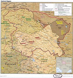
bottom: A map of the disputed Kashmir region with the two Pakistan-administered areas shaded in sage-green.[1]
လွင်ႈၽိတ်းပိူင်ႈ Lua: Coordinates must be specified on Wikidata or in |coord=.
Interactive map of Azad Kashmir
ၵူဝ်ႇဢေႃးတိၼဵတ်ႉ- 33°50′36″N 73°51′05″E / 33.84333°N 73.85139°E / 33.84333; 73.85139
Administered byPakistan
EstablishedOctober 24, 1947 (Azad Kashmir Day)
CapitalMuzaffarabad
Largest cityMuzaffarabad
Government
 • TypeSelf-governing state under Pakistani administration[2][3]
 • BodyGovernment of Azad Kashmir
 • PresidentSultan Mehmood Chaudhry
 • Prime MinisterChaudhry Anwar-ul-Haq
 • Chief SecretaryDawood Muhammad Barech (BPS-21 PAS)
 • LegislatureAzad Jammu and Kashmir Legislative Assembly
 • Supreme CourtSupreme Court of Azad Jammu and Kashmir
လႅၼ်တီႈ
 • ႁူမ်ႈလေႃး
13,297 လွၵ်းၵီႇလူဝ်ႇမီႇတႃႇ (5,134 လွၵ်းလၵ်း)
ႁူဝ်ၼပ်ႉၵူၼ်း
 (2017)
 • ႁူမ်ႈလေႃး
Increase 4,045,366
DemonymAzad Kashmiri
ပွတ်းတွၼ်ႈၶၢဝ်းယၢမ်းUTC+05:00 (PKT)
ISO 3166 codePK-AJK
Main language(s)
Literacy rate (2017)74%[4]
HDI (2019)0.612 Increase[5]
Medium
Divisions3
Districts10
Tehsils33
Union Councils182
ဝႅပ်ႉသၢႆႉwww.ajk.gov.pk
  1. မီးလွင်ႈၽိတ်းပိူင်ႈ : Invalid <ref> tag; no text was provided for refs named tertiary-kashmir
  2. မီးလွင်ႈၽိတ်းပိူင်ႈ : Invalid <ref> tag; no text was provided for refs named brit
  3. "Kashmir profile". BBC News. November 26, 2014. Archived from the original on July 16, 2015. Retrieved July 24, 2015.
  4. Tahir, Pervez. "Education spending in AJK". The Express Tribune. Archived from the original on March 20, 2022. Retrieved December 8, 2022.
  5. "Sub-national HDI - Area Database - Global Data Lab". hdi.globaldatalab.org. Archived from the original on September 23, 2018. Retrieved March 15, 2020.