သဵင်ႉႁႄးလႄးၼႃႇ
Appearance
သဵင်ႉႁႄးလႄးၼႃႇ | |||
|---|---|---|---|
| |||
|
ၶေႃႈၶၼ်ပၢၵ်ႇ "Loyal and Unshakable" | |||
|
ၵႂၢမ်းၸိုင်ႈမိူင်း: "God Save the Queen" | |||
| Unofficial anthem: "My Saint Helena Island" | |||
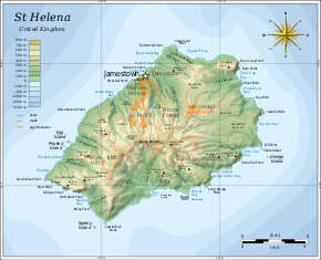
 Map of Saint Helena | |||
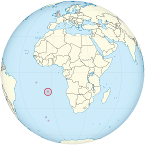
 Location of Saint Helena in the southern Atlantic Ocean | |||
| Sovereign state | United Kingdom | ||
| Colonial charter | 1657 | ||
| Crown colony | 22 April 1834 | ||
| Current constitution | 1 September 2009 | ||
| ဝဵင်းငဝ်ႈၸိုင်ႈ |
Jamestown 15°56′S 05°43′W / 15.933°S 5.717°W | ||
| Largest city |
Half Tree Hollow 15°56′0″S 5°43′12″W / 15.93333°S 5.72000°W | ||
| ၽႃႇသႃႇၸႂ်ႉၼႂ်းလုမ်း | English | ||
| ၵူၼ်းၸႃႇတိ |
| ||
| လူင်ပွင်ၸိုင်ႈ | Devolved parliamentary dependency under a constitutional monarchy | ||
• Monarch | Elizabeth II | ||
• Governor | Philip Rushbrook | ||
| လုမ်းတႅၼ်းၽွင်း | Legislative Council | ||
| Government of the United Kingdom | |||
• Minister | Tariq Ahmad | ||
| ဢေႇရိယႃႇ | |||
| ၼႃႈလိၼ်သုင်သုတ်း | 818 မီႇတႃႇ (2,684 ထတ်း) | ||
| ႁူဝ်ၼပ်ႉၵူၼ်း | |||
• သဵၼ်ႈမၢႆႁူဝ်ႁိူၼ်း 2016 | 4,534 | ||
| ငိုၼ်း | Saint Helena pound (£) (SHP) | ||
| ၶၢဝ်းယၢမ်းၼႃႈလိၼ် | UTC±00:00 (GMT) | ||
| ပိူင်ဝၼ်းတီႈ | dd/mm/yyyy | ||
| ပိူင်သၢႆလူတ်ႉ | left | ||
| ၶူတ်ႉတႄႇလီႇၾူင်း | +290 | ||
| UK postcode |
STHL 1ZZ | ||
| ၶူတ်ႉ ISO 3166 | SH-HL | ||
| TLD ဢိၼ်ႇထႃႇၼႅတ်ႉ | .sh | ||


