ၼႃႈလိၼ် ပႃႇလႅတ်ႇသတိၼ်းၼီးယႅၼ်း
Appearance
| ၼႃႈလိၼ် ပႃႇလႅတ်ႇသတိၼ်းၼီးယႅၼ်း الأراضي الفلسطينية al-Arāḍī al-Filasṭīniyya | |
|---|---|
 | |
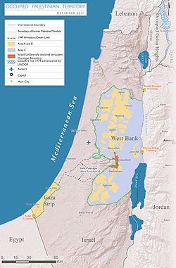
 Palestinian Territories according to a Green Line based definition | |
| ဝဵင်းယႂ်ႇသေပိူၼ်ႈcities | |
| Languages | |
| ၸၢဝ်းၶိူဝ်း | |
| Demonym | |
| ပိုၼ်ႉတီႈ ဢၼ်ပိူင်ႇ | |
• ၼမ်ႉ (%) | 3.5 |
|
5,860 km2[1] (of which Dead Sea: 220 km2) | |
| 360 km2[2] | |
| ႁူဝ်ၼပ်ႉၵူၼ်း | |
• Palestinians (2014) | 4,550,000[3] |
• Settlers (2012) | 564,000 |
• 2007 သဵၼ်ႈမၢႆႁူဝ်ႁိူၼ်း | 3,719,189 (Pal.)[3][4] |
| HDI (2010) |
0.645[5] ၵၢင် · 97th |
| ငိုၼ်းတွင်း |
|
| ၶၢဝ်းယၢမ်းၼႃႈလိၼ် | EET (UTC+2) |
• ၶၢဝ်းမႆႈ (DST) | EEST (UTC+3) |
| ပိူင်သၢႆလူတ်ႉ | right |
| ၶူတ်ႉတႄႇလီႇၾူင်း | +970d |
| ၶူတ်ႉISO 3166 | PS |
| Internet TLD | |
| |
ၽိုၼ်ဢိင်
[မႄးထတ်း | မႄးထတ်းငဝ်ႈငႃႇ]- ↑ Israeli documentation provides population figures for the whole of Jerusalem without specific information on East Jerusalem being provided.
- ↑ CIA – The World Factbook. cia.gov. Archived from the original on 6 May 2014။ Retrieved on 28 November 2012။
- ↑ CIA – The World Factbook. cia.gov. Archived from the original on 8 June 2014။ Retrieved on 28 November 2012။
- ↑ 3.0 3.1 Archive copy.
- ↑ 4.0 4.1 Archive copy.
- ↑ Human Development Reports. Hdr.undp.org. Archived from the original on 2011-11-15။ Retrieved on 2016-06-10။
