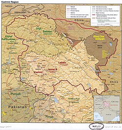
ဢႃႇၸတ်ႉၶႅတ်ႉသ်မီႇယႃႇ
Appearance
(လုၵ်ႉတီး Azad Kashmir ၼႆႈသေ ၶိုၼ်းပိၼ်ႇဝၢႆႇမႃး)
ဢႃၸတ်ႉ ၵျမ်မူ လႄႈ ၶႅတ်ႉသ်မီႇယႃႇ
Āzād Jammū̃ o Kaśmīr | |
|---|---|
Administered by Pakistan as a self-administrative territory | |
| လွင်ႈၽိတ်းပိူင်ႈ Lua: Coordinates must be specified on Wikidata or in |coord=. Interactive map of Azad Kashmir | |
| Coordinates: 33°50′36″N 73°51′05″E / 33.84333°N 73.85139°E | |
| Administered by | Pakistan |
| Established | October 24, 1947 (Azad Kashmir Day) |
| Capital | Muzaffarabad |
| Largest city | Muzaffarabad |
| Government | |
| • Type | Self-governing state under Pakistani administration[2][3] |
| • Body | Government of Azad Kashmir |
| • President | Sultan Mehmood Chaudhry |
| • Prime Minister | Chaudhry Anwar-ul-Haq |
| • Chief Secretary | Dawood Muhammad Barech (BPS-21 PAS) |
| • Legislature | Azad Jammu and Kashmir Legislative Assembly |
| • Supreme Court | Supreme Court of Azad Jammu and Kashmir |
| လႅၼ်တီႈ | |
• ႁူမ်ႈလေႃး | 13,297 လွၵ်းၵီႇလူဝ်ႇမီႇတႃႇ (5,134 လွၵ်းလၵ်း) |
| Population (2017) | |
• ႁူမ်ႈလေႃး | |
| Demonym | Azad Kashmiri |
| ပွတ်းတွၼ်ႈၶၢဝ်းယၢမ်း | UTC+05:00 (PKT) |
| ISO 3166 code | PK-AJK |
| Main language(s) |
|
| Literacy rate (2017) | 74%[4] |
| HDI (2019) | 0.612 Medium |
| Divisions | 3 |
| Districts | 10 |
| Tehsils | 33 |
| Union Councils | 182 |
| ဝႅပ်ႉသၢႆႉ | www |
ၶေႃႈမၢႆတွင်း
[မႄးထတ်း | မႄးထတ်းငဝ်ႈငႃႇ]ၽိုၼ်ဢိင်
[မႄးထတ်း | မႄးထတ်းငဝ်ႈငႃႇ]- ↑ မီးလွင်ႈၽိတ်းပိူင်ႈ : Invalid
<ref>tag; no text was provided for refs namedtertiary-kashmir - ↑ မီးလွင်ႈၽိတ်းပိူင်ႈ : Invalid
<ref>tag; no text was provided for refs namedbrit - ↑ "Kashmir profile"၊ BBC News၊ November 26, 2014။
- ↑ Tahir၊ Pervez။ "Education spending in AJK"။
- ↑ Sub-national HDI - Area Database - Global Data Lab.
ပိူင်ထၢၼ်ႈ:
- Pages with script errors
- Pages using gadget WikiMiniAtlas
- Pages with non-numeric formatnum arguments
- Pages with reference errors
- ပွင်ႈၵႂၢမ်း ဢၼ်ပႃး ၶေႃႈသပ်းလႅင်းပွတ်း
- Short description with empty Wikidata description
- Pages using infobox settlement with bad settlement type
- Coordinates not on Wikidata
- Pages using infobox settlement with unknown parameters
- Pages using infobox settlement with image map1 but not image map


